
“Being human is itself difficult, and therefore all kinds of settlements (except dream cities) have problems. Big cities have difficulties in abundance, because they have people in abundance.”
― Jane Jacobs, The Death and Life of Great American Cities
Started at Metro Champs des Mars.

There is a lot of construction in this location, the big one being the new hospital. It’s going to be interesting to see how this Metro station handles the massive increase in traffic once the hospital is completely open.


Familiar looking sculpture in front of a hospital building at Saint Denis.

Now classic facadism, after all, what’s a major building downtown without a heritage reference? And it works very well despite the fact that the steeple is dwarfed by the new building. These neighborhoods have sure seen their changes.

The main western section of Viger Square is closed.


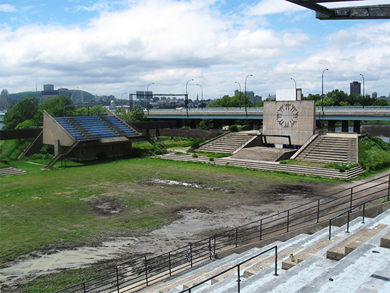
Looks strangely abandoned, reminding me of Place des Nations when it was in decline.
Home of the l’Union Francaise.

Bike path leads to Old Montreal and Place Viger, former railway station that developers lusted after for decades, currently being transformed into a mixed use project.

The two eastern sections of Viger Square are open. This is Force (fountain sculpture) (1985), by Claude Théberge.

And the square is also famous for homeless people, seems like some are well organized.

535 Viger est Edifice Gilles Hocquart Bibliotheque et Archives Nationales.


A few more from the end of the square.


Some major icons in this view, Radio Canada tower, Jacques Cartier Bridge, Molson clock.
Old building at Saint Andre and Viger.

And this is what Viger Square covers.

Radio Canada. Le Faubourg à m’lasse was demolished for this project, and there is just as much parking space on the other side of the complex.

I took this shot before heading north of the expressway because I have a hard time trying to imagine who would buy those condos and why – your balcony gives you an unprecedented view into a below grade expressway that must be incredibly noisy and polluted at rush hour.

In the parking lot.

This church, Saint Pierre Apotre, at the corner of de la Visitation and Rene Leveseque, has a massive steeple.

One last look at the Radio Canada / CBC tower.

Turning left on Rene Levesque at Alexandre DeSeve. Paroisse Sainte Brigide. I really hate when I am unable to get the whole steeple in but it happens a lot in this town.

Cut back through a tiny street called rue Lonergan.

And that led me to this almost impossibly charming little street called rue Dalcourt.


And a section of Sainte Rose runs between Delcourt and Alexandre DeSeve.

Small green lane running west.

Couldn’t resist this almost parodic shot of my “Verdun Lanes” style.

And voila! We are on Sainte Catherine street in the village.


And back down Alexandre DeSeve. What looks like a typical lane (except for the gate) is actually rue Gareau.

On the right is Parc Charles S. Campbell (of whom there are three parks named in Montreal {something I discovered sans google in the late 80’s when I was photographing parks and green spaces on the island of Montreal}).
It’s a nice multi purpose inter generational neighborhood park.

Just south of the park is Habitation Sainte Brigide. I am assuming that it is social housing of some kind. And a quick google search reveals it is indeed a senior’s residence.

Detail of Sainte Brigide steeple.

On the way back to Rene Levesque.

Russian Orthodox church at the corner of Champlain and Rene Levesque.

Some history (hope you can make it out).

Decided to turn up Cartier.

It struck me as being unusual to see laundry hanging on a balcony so high as if we in North America have insisted on some kind of sanitized version of reality above the 3rd floor. Just a thought…

Looking back from in front of the apartments (which are on Sainte Rose).

Different take on outdoor stairs as I continue up Cartier.

Sainte Catherine and Cartier. Afraid we are going to use up all our space. When was the last time you have heard of the city or your borough actually creating public space?

Looking east down Sainte Catherine.

One of my all time favorite public sculptures in the park behind Papineau Metro.

Because it’s a cool sign.

Outside stairs going to the third floor on Cartier.

Cartier temporarily ends at the park where the traffic on Papineau is diverted towards the bridge but looking back from the bike path it seems pretty cool to have a park for a back yard.

Took Malo over to a big park and just after I took this picture my battery died.

So the next walk will not start right there, but I will pick up the trail here next time. A very dull day was turned into a pretty cool little adventure through the city. So long for now, says your favorite photoflanneur!!
And here is a 90% accurate map of the walk.


good one Neath. Speaking of public spaces and Jane Jacobs,she was instrumental in New York City passing a by-law that requires developers to create a public space in proportion to the number of stories of their buildings, The result is some great places to sit and reflect,or people watch in the middle of mid-town. It should be so in every city,
Couldn’t agree more 🙂
Hey nice post! Love your writing!! You should check out my blog realsisterhood.com if you get a chance!!
Pingback: Walk # 2 Part 1 | PostArctica·